Showing posts with label walks. Show all posts

Friday, January 28, 2022

Mt Direction

I have always been fond of Mount Direction – this very recognisable double-humped hill that rises sharply from the eastern shore of the Derwent. It’s a way upriver from the city, but you can see it from a lot of vantage points. These first two pics are from paddling excursions in Cornelian Bay and off Taroona High School, respectively.


I've also drawn it many times; its one of those shapes I have in my head and I can knock out an inaccurate but recognisable Selfs Point Fuel Terminal and Mt Direction scribble in five minutes.

Anyway – now I have climbed it finally. Michael and I set off mid-morning on Australia Day holiday, 26 January (by the time you read this maybe the day will have been changed). It was a great day for strenuous climbing. 

You park at Risdon Brook Dam, stroll around the left side of the dam and then its gets confusing for a bit but before long you turn a corner and there is a slope like this: / that just goes right to the top. It is hellishly steep. The official page for the walk with map etc is here, and it rates it as four Difficulty Units out of a possible five.

But fortunately it was a cool overcast morning and we both enjoyed it a lot. We took a LOT of water and I would recommend that (you can fill bottles at the car park). But it's only 4km to the top, it doesn't take that long. 


We saw heaps of wallabies on the lower slopes, quite used to people. We didn’t know they were there in a lot of cases until we got almost within touching distance and suddenly one would launch itself out of the grass then watch us from five metres away. We saw one very brown echidna. And we were often mobbed by butterflies, common orange ones that might have been Australian Painted Ladies.


That peak over there is Gunners Quoin, which is a 17km return walk from the same start point. One to think about for the future.


At the top is a cairn and a ‘Communications Station’ ie a shed with aerials. The track just vaguely peters out just below it. 


This is the view from the top, looking north/upriver. I recognised Claremont Golf Club and the Bridgewater Bridge but I was really struggling for other landmarks. These are Hobart’s far northern suburbs and it’s not my patch, man.


The only time I feel like taking a selfie is when I have just climbed something. That's why we look smug.


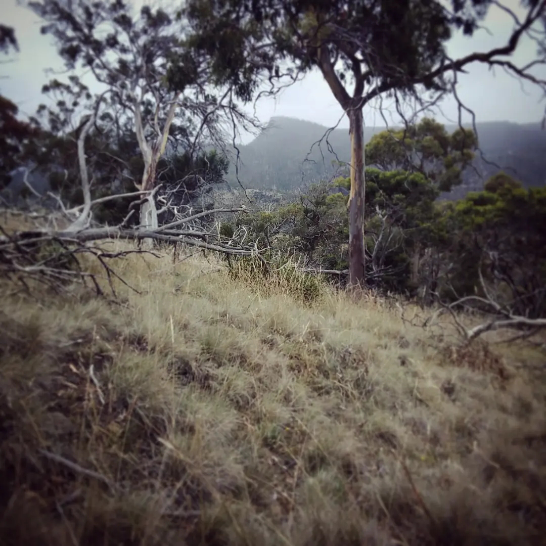
I assumed that there'd be a clear track from the cairn at the top to a good view of the city; but not so. We picked our way over broken wood and tussocks to get this view to the south. A lot of the city is obscured by the Queens Domain, and of course the misty conditions don't help. But I wanted to at least see the white tanks on Self's Point which always go hand in hand with Mt Direction in my mind.


We climbed back down carefully, with no slips or trips. We did get slightly lost but Michael sorted us out. I got the feeling that the tracks were mostly used for going elsewhere and not many people bothered climbing to the top; possibly because the city view is not all that clear. Anyway – we both loved it and I am keen to go again on a clearer day.

Tuesday, January 26, 2021

Beach Week part one

We just spent a week at Swansea, 2 hours up the east coast from Hobart. We four went with Imp, Ed, Karri & Miah, and stayed at this big stretched-out beach house at Coswell Beach, not far from town. It was fantastic! Halfway through the second day I realised I was getting some deep relaxation that just isn't possible at home, where there is so much to do. And Elf was relaxed, the boys were enjoying being with their cousins and having their own space; it all worked really well.


The block is very big, with the house at the top and a gradual slope down towards the beach. After a 4-minute walk you pop out of the bush and the beach is right there. The beach was very quiet; we only ever saw the odd dog walker. No-one else was in the water.


We had dawn swims, morning swims, afternoon swims and evening swims, and we each had a paddle on the wave ski. We mostly look for still water to paddle (despite the name), but Michael took it out through the churning surf, and Elf and I both successfully got it out through much calmer waves. The stakes are higher, and getting tipped out is at least 50% probability, so you are swapping some of the relaxation for a touch of excitement.


We also took the wave skis to Bagot Point, which sticks out from the mainland opposite the more famous Coles Bay on the Freycinet Peninsula. This is a great spot where you can park on the beach, which always gives me a buzz. You could easily paddle or even swim over to the other side here.

We got there more conventionally when Ed suggested a walk up The Hazards, which are five peaks that overlook the famous Wineglass Bay in the Freycinet National Park. Specifically he wanted to climb Mt Amos, the 2nd tallest. Michael and Marcus were keen, and Miah would have come except for a sore toe that she is supposed to be resting. I said I would come along, but after watching this video I thought there was a good chance I wouldn't get to the top.

But I did! We four all did.


It was pretty hard climbing for me. Ed and Michael had good boots but Marcus and I had Blundstones and mine are pretty old and low on grip. This is a VERY slippery walk and is absolutely not to be attempted in wet conditions. The Hazards are granite, and there is both very scratchy grippy red granite and very slick and smooth grey granite. Here and there are little runnels of fresh water coming from I don't know where; little springs I guess. When you step on a smooth section with a wet boot, you really know it! It was just rock climbing at times; just looking for foot- and hand-holds. Sometimes there was nothing for your hands at all; just a crack to jam your feet in. I am not a rock-climber (fat with puny arms and stiff joints) so I didn't enjoy this much, in the doing.

At the top I wasn't exhausted like I might be from walking a steep track with lots of steps. It was more brain work than leg work, maybe. But I was exhilirated to have made it and LOOK at the view! Wineglass Bay is often depicted on Tasmanian tourism posters and so on; its so stunning. There are easier ways to than this to get a look at it; despite this I have never seen it with my own eyes despite living here nearly all my life.


The climb down was scarier than going up. Upwards you are able to lean into the slope; downwards I just found I had to slide on my butt a lot. Which of course took me back to this misadventure in India. Walking the Lost World with Michael was also a climb/scramble but not remotely slippery. 

When we reached the bottom we chatted to a ranger; who told us how Wineglass Bay got its name. I am surprised I had never heard this before; in whaling days they would trap southern right whales in the bay, slaughter them, and then the bay had the appearance of a glass of red wine. Ugh.

We met up with Elf and Imp and the girls at Honeymoon Bay and rewarded ourselves with a swim.


Sunday, October 14, 2018

Lost World walk

Michael was keen to go for a walk on the mountain today. I suggested a short walk so I could keep him company and not take too big a chunk out of my Sunday. The Lost World track looked like a good one on the map - steep but interesting.

We can see the Lost World area from our house. The small peak is Mt Arthur
(I think I have told people in the past that it's Collins Cap but that is quite a bit further away)
I imagined a track of hundreds of steps, in fact there was not one. Instead, think of large boulders, with arrows scratched on them to keep you going in the right direction.

My guide, the nimble-footed Michael, at the top of the descent.
The Big Bend, Pinnacle Road - we parked the car near the white car in the centre.
The first 10 metres of the track was a peat bog, and after that is a dry rock scramble.
We descended for about 20 minutes. The Lost World Track meets the Old Hobartians track down below, but that is closed still since the August storms. I was happy just to get that far and turn around. In fact it was such a steep and laborious descent that a picked a spot with a good view and told Michael I would wait there for him. He went down to explore.

The 'Organ Pipes' on the eastern face of Mt Wellington/kunanyi are huge dolerite columns.
Here further north there are smaller ones – I always think of these as the Little Organ Pipes.
Michael is at the very centre of this pic. You can see where at some stage of geological time
a lot of the columns fell and smashed. They are distinctly hexagonal in section.


The climb back up begins
I am probably haunted a bit by my near-miss when I got lost walking in India. I just did a search of the blog and I realise now I haven't written about it here, except for this tiny snippet. Anyway it has made me uber-cautious about getting lost or injured walking out in the bush. But now I know the lay of the land here, I'll be happy to come back and push on further.

The amazing part was how fast it was to get back up to the top. The process of choosing foot- and hand-holds on the way down is so slow, that it actually is way quicker going up.

Sunday, February 04, 2018

North Hobart's tiny house district

I have worked out that in hour I can walk from Red Jelly up here to North Hobart and back. Or I can catch the bus up that way then walk around and have a really good look THEN walk back. I have found a big blackberry bush that I'd quite like to revisit, in a little thru-way between houses.

This is around Smith, George and Wellington Streets, between Argyle St and Letitia St. Some tiny tiny houses around here. (Photos from Google Streetview)