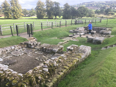
Chesters is a stately home, named in the distant past for the "castra" or Roman camp which became the fort. The ruins of the fort were plundered for building materials over hundreds of years. The Roman bridge was demolished by the Saxons and the stone used to build a church. Nathaniel Clayton bought Chesters in 1796 and levelled whatever was left, and grassed it over for a park. His son John picked up and kept interesting antiquities throughout his childhood. When John inherited the estate he set about digging to find more; and in the process became one of the founders of the science of archaeology. John's nephew, another Nathaniel, continued the excavations and built a museum to house the artefacts they found.
We were the only people there when we arrived. It was a cool showery day but not unpleasant, and it was just nice to be out in the middle of Northumbrian farmland with the horses, sheep and birds. Nothing remains that is more than knee-high so as we approached the excavations over undulating paddocks we did not see anything until we were practically on top of the main fortress gate.
Standing there looking at our little pamphlet and down at the ruins, we experienced that telescoping of time, where you vividly imagine what was happening on that spot nearly 2000 years ago. The large gates were designed to pivot on a pin in a round hole in the stone foundation, and the iron collar of the hole still remained.
The ruins are very hands on; there are no signs telling you to keep back, and the only fences are simply designed to stop visitors falling into holes. The boys were clambering all over the ruins in no time and Elf and I joined them.
Something about 'ruins' that catches me every time is assuming they date to a specific time, and were used for a specific purpose by a specific group of people. Then when you look into it, the truth is that a site began being used at some point, and then a continuum of people, purposes and structures came and went.
But the principal occupants of this site were soldiers of a cavalry regiment which came from a distant edge of the Roman world, Asturias in Spain. A later garrison was The First Cohort of Dalmatians from present day Croatia. The soldiers slept in compartments in the barracks in groups of three, each with their horse and a slave groom nearby.
Within the fort boundary are ruins of the commandant's house, a temple (with lucky phallus bas relief on the floor) and a bath house. The latter was one of the most interesting sights; the pillars that supported the raised floor remain, and a tunnel houses the furnace which heated the air which circulated warming the floor.
 |
| Lucky phallus |
 |
| The garrison's payroll and other valuables were kept in this vault. |
 |
| The main east-west road through the fort |
 |
| These are the foundations of the main gate, facing the barbarians to the North. |
 |
| This furnace heated the water and air for the bath house. |
 |
| The hot air circulated around these pillars which supported the floor of the bath house. |
 |
| Outside the fort this is a section of Hadrian's Wall which continued down to the North Tyne river in the distance. There was once a fortified bridge, and the wall continues on the other bank. |
 |
| The boys loved being able to just climb around on the ruins |
 |
| The on-site museum has hundreds of artefacts unearthed since the 1700s. |
 |
| Michael Rees, on a Roman wall, in a field, Northumberland, United Kingdom 2016 |
 |
| Through the trees you can see Chesters, the stately home associated with the ruins. |
We passed from Northumberland into Durham County and then into Yorkshire. In general the towns were unsightly but the countryside was stunning, especially around Tow Law and Castleside. We also passed Snods Edge, Tofts Hill and Throckington.
As we approached York it was beginning to get dark, and the GPS (possibly offended that we had bought a map) was refusing to work. Our roadmap was of no assistance with navigating downtown York, but fortunately we found a 'tourist information bay' and pulled in there to get an idea of where we were. As we fumbled our way towards our B&B in Monkgate, the GPS came to life again, and we were at our destination safe and sound.
Our apartment at Monkgate Guest House had two bedrooms and a bathroom. We had to go through the boys' room to get to the bathroom (which had a very squeaky door, and one switch for lights and the noisy fan).
We went down the road to an Indian restaurant called The Viceroy for dinner. Two stars, disappointingly sweet curries again. We decided that would be our last attempt at Indian food in the UK.


No comments:
Post a Comment